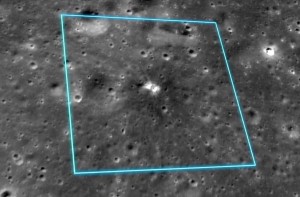
NASA’s Lunar Reconnaissance Orbiter (LRO) acquired images of the lunar surface before and after the largest recorded explosion occurred on the surface.
On March 17, 2013, an object the size of a small boulder hit the surface in Mare Imbrium and exploded in a flash of light nearly 10 times as bright as anything ever recorded before.
This bright flash was recorded by researchers at NASA’s Marshall Space Flight Center in Huntsville with coordinates 20.6°N, 336.1°E. The Lunar Reconnaissance Camera (LROC) scientists were able to obtain observations before and after the impact. Comparing the actual size of the crater to the brightness of the flash helps validate impact models.
LROC’s first set of post-impact flash images acquired on May 21, 2013 by the Narrow Angle Camera (NAC) were targeted on the Marshall-reported coordinates and numerous small surface disturbances (“splotches”) were detected by comparing the pre- and post-flash images, but no new crater was found.
A second set of NAC images was acquired on July 1, 2013, showing three faint ray-like features and several chains of splotches and asymmetric splotches that generally pointed to a common area west of the Marshall coordinates. A NAC pair was targeted on that convergence point for July 28, 2013; comparison of this third set of images with preexisting coverage revealed a new crater.
The crater itself is small, measuring 18.8 meters (61.7 feet) in diameter, but its influence large; debris excavated by the sudden release of energy flew for hundreds of meters. More than 200 related surficial changes up to 30 kilometers (19 miles) away were noted.
The results are published in the January 31 edition of the journal Icarus.
The March 17 impact crater is one of thousands of craters being mapped by the instrument. The LROC team is going back to images taken in the first year or two and comparing them to recent images. Called temporal pairs, these before/after images enable the search for a range of surface changes, including new impact craters, formed between the time the first and second image were acquired.
As of January 1, 2015, LROC has acquired about 10,000 before and after image pairs.
Launched on June 18, 2009, LRO has collected a treasure trove of data with its seven powerful instruments, making an invaluable contribution to our knowledge about the moon. LRO is managed by NASA’s Goddard Space Flight Center in Greenbelt, Maryland, for the Science Mission Directorate at NASA Headquarters in Washington.
To download the visualizations of these impacts, visit:
https://svs.gsfc.nasa.gov/goto?4242
To read more about the March 17, 2013, impact crater, visit LROC’s website:
https://lroc.sese.asu.edu/posts/770
