ANCHORAGE, AK – The State of Alaska Division of Homeland Security and Emergency Management (DHS&EM) is assisting communities in preparation for breakup along Alaska’s major river systems this spring. Breakup is a time of both excitement and anxiety. Residents anticipate the ability to travel along the rivers, but are also concerned with the threat that ice jam flooding poses to their communities.
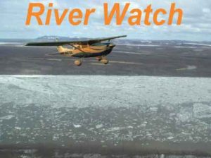
Each spring the River Watch program renews a partnership between DHS&EM and the National Weather Service (NWS). The Alaska Pacific River Forecast Center conducts aerial observations of rivers prone to ice jam flooding. The team provides flood warnings and assists communities responding to flood emergencies. The River Watch partnership has existed for more than 30 years. The first River Watch team is planning to begin surveillance flights on the Upper Yukon and Kuskokwim Rivers the first week of May.
DHS&EM is inviting members of the media to fly with the teams as they conduct their river observations along the Yukon and Kuskokwim Rivers. Yukon River teams will be based in Fairbanks, Galena, and St. Mary’s. Kuskokwim River teams will be based in Aniak and Bethel. All other travel and lodging will be the responsibility of the media outlet. River Watch emergency response work will take priority to all other River Watch missions, including allowing media to fly with River Watch. Seating is limited and will be given on a first come first serve basis.
“The river breakup forecast for this year calls for an average breakup. We have seen average forecast years with no significant flooding, and average forecast years with widespread major flooding. River breakup is a dynamic event and the best way to identify dangerous conditions is to fly the river and evaluate the ice as it moves,” said Bryan Fisher, DHS&EM Chief of Operations. “As we have for many years, River Watch will be in place to provide up-to-date flood information to communities, and help respond if flooding occurs.”
The NWS Alaska-Pacific River Forecast Center reports the potential for flooding as average for most parts of the state. This year’s breakup map and flood potential can be found at https://www.weather.gov/aprfc/floodpotential
The River Watch teams, NWS, and DHS&EM will be providing up-to-date river information on Twitter through the hashtag #AKRiverWatch
Follow the Division of Homeland Security and Emergency Management on Twitter @AlaskaDHSEM and on Facebook. [xyz-ihs snippet=”Adsense-responsive”]
