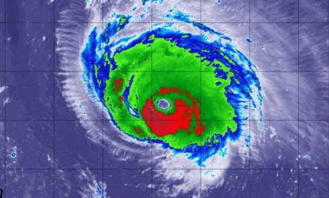
NASA-NOAA’s Suomi NPP satellite passed over the eye of powerful Category 4 Hurricane Florence and found the storm over 400 miles in diameter and the capability to generate very heavy rainfall.
At 8 a.m. EDT on Wednesday, Sept. 12, NOAA’s National Hurricane Center (NHC) warned “Dangerous Florence heading toward the U.S. southeast coast and is expected to bring life-threatening storm surge and rainfall to portions of the Carolinas and Mid-Atlantic States.”
Putting the Size and Surge of the Storm in Perspective
Florence is about 400 miles in diameter. For an understanding of how large the system is 400 miles is the distance from Baltimore, Maryland to Boston, Massachusetts.
This is a life-threatening situation. In some areas, the NHC said that storm surge could be as high as 13 feet, which is over the first floor of a house or building.
NHC said “Persons located within these areas should take all necessary actions to protect life and property from rising water and the potential for other dangerous conditions. Promptly follow evacuation and other instructions from local officials.” A Storm Surge Warning means there is a danger of life-threatening inundation, from rising water moving inland from the coastline, during the next 36 hours in the indicated locations.
Warnings and Watches: Storm Surge, Hurricane, Tropical Storm
The warnings and watches are numerous from Virginia to South Carolina. A Storm Surge Warning and a Hurricane Warning are both in effect for South Santee River, South Carolina to Duck, North Carolina and the Albemarle and Pamlico Sounds, including the Neuse and Pamlico Rivers. A Storm Surge Watch and a Hurricane Watch is in effect for Edisto Beach, South Carolina to South Santee River, South Carolina.
A Tropical Storm Warning and Storm Surge Watch is in effect for north of Duck, North Carolina to the North Carolina/Virginia border. A Tropical Storm Watch is in effect for north of the North Carolina/Virginia border to Cape Charles Light, Virginia and for the Chesapeake Bay south of New Point Comfort.
A NASA Satellite View of a Massive Rainmaker
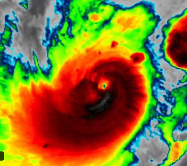
On Sept. 12 at 2:12 a.m. EDT (0612 UTC) the Visible Infrared Imaging Radiometer Suite (VIIRS) instrument aboard NASA-NOAA’s Suomi NPP satellite captured an infrared view of Florence (above). VIIRS infrared imagery showed that the eye of Florence remains very distinct. There has been little change to the cloud top temperatures surrounding the eye overnight. The VIIRS imagery also showed that the overall structure has become slightly more symmetric.
Coldest cloud top temperatures of strongest thunderstorms were in the eyewall, the area of thunderstorms surrounding the open eye. Those storms had cloud tops as cold as or colder than minus 80 degrees Fahrenheit (minus 62.2 Celsius). They were surrounded by powerful storms with cloud tops as cold as minus 70 degrees Fahrenheit (minus 56.6 degrees Celsius).
NASA research has shown that cloud top temperatures in excess of 63F/53C can produce heavy rainfall. Florence has a very wide area of storms where cloud tops are colder than that threshold, indicating that the storm has the capability to generate very heavy rainfall over a large area.
NHC said Florence is expected to produce heavy and excessive rainfall in the following areas: Coastal North Carolina…20 to 30 inches, isolated areas may see 40 inches; South Carolina, western and northern North Carolina…5 to 10 inches, isolated areas may see 20 inches; Elsewhere in the Appalachians and Mid-Atlantic states…3 to 6 inches, isolated areas may see 12 inches.
Florence’s Status on Sept. 12 at 8 a.m. EDT
At 8 a.m. EDT (1200 UTC) on Sept. 12, the NHC said the eye of Hurricane Florence was located near latitude 29.4 degrees north and longitude 70.7 degrees west. That’s about 530 miles (855 km) southeast of Cape Fear, North Carolina.
Maximum sustained winds are near 130 mph (215 kph) with higher gusts. Florence is a category 4 hurricane on the Saffir-Simpson Hurricane Wind Scale. Hurricane-force winds extend outward up to 70 miles (110 km) from the center and tropical-storm-force winds extend outward up to 175 miles (280 km).
Strengthening is forecast through tonight. While some weakening is expected on Thursday, Florence is forecast to be an extremely dangerous major hurricane when it nears the U.S. coast.
Florence’s Current Forecast Path
Florence is moving toward the west-northwest near 17 mph (28 kph), and this motion is expected to continue this morning. A motion toward the northwest is forecast to begin by this afternoon and continue through Thursday. Florence is expected to slow down considerably by late Thursday into Friday, and move slowly through early Saturday. On the forecast track, the center of Florence will move over the southwestern Atlantic Ocean between Bermuda and the Bahamas today, and approach the coast of North Carolina or South Carolina in the hurricane warning area on Thursday and Friday.
NHC forecasters caution that the path may change and residents along the southeastern U.S. coast should stay vigilant.
Source: NASA


