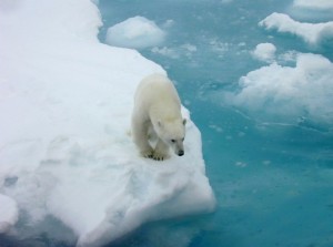
A new NOAA-led report shows that Arctic air temperatures continue to rise at more than twice the rate of global air temperatures, a phenomenon known as Arctic amplification. Increasing air and sea surface temperatures, declining reflectivity at the surface of the Greenland ice sheet, shrinking spring snow cover on land and summer ice on the ocean, and declining populations and health of some polar bear populations are among the observations released today in the Arctic Report Card 2014.
“Arctic warming is setting off changes that affect people and the environment in this fragile region, and has broader effects beyond the Arctic on global security, trade, and climate,” Craig McLean, acting assistant administrator for the NOAA Office of Oceanic and Atmospheric Research, said during a press conference today at the annual American Geophysical Union Fall Meeting in San Francisco. “This year’s Arctic Report Card shows the importance of international collaboration on long-term observing programs that can provide vital information to inform decisions by citizens, policymakers and industry.”
McLean joined other scientists to release the Arctic Report Card, an annual update provided since 2006, that summarizes changing conditions in the Arctic. Some 63 authors from 13 countries, United States and other nation’s federal agencies and academia contributed to the peer-reviewed report. This year’s report features updates on key indicators as well as a new report on the status of polar bears. Major findings of this year’s report include:
-
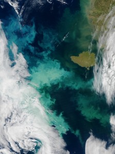
As sea ice retreats in summer, more sunlight reaches the upper layers of the sea, triggering increased blooms of phytoplankton such as here in the Bering Sea this fall. (Credit: NASA) Air temperatures: The jet stream pattern during early 2014 sent extreme cold air southward into eastern North America- and central Russia and extreme warm air northward into Alaska and northern Europe. Alaska recorded temperature anomalies more than 18 degrees Fahrenheit (10 degrees Celsius) higher than the January average.
- Snow cover: Snow cover across the Arctic during spring of 2014 was below the long-term mean of 1981-2010, with a new record low set in April for Eurasia and North America’s June snow extent the third lowest on record. Snow disappeared three to four weeks earlier than normal in western Russia, Scandinavia, the Canadian subarctic and western Alaska due to below average accumulation and above normal spring temperatures.
- Sea ice: The extent of sea ice in September 2014 was the sixth lowest since satellite observations began in 1979. The eight lowest sea ice extents since 1979 have occurred in the last eight years (2007-2014). At the time of maximum ice extent in March 2014, there had been a modest increase in ice thickness and age relative to the same time in 2013. Despite this, there is still much less of the oldest, thickest (greater than 13 feet or 4 meters) and most resilient ice than in 1988, when the oldest ice made up 26 percent of the ice pack compared to 10 percent this year.
- Arctic Ocean temperature: As sea ice retreats in summer, sea surface temperature (SST) in all the seas of the Arctic Ocean is increasing. The most significant linear trend is in the Chukchi Sea, northwest of Alaska, where SST is increasing at a rate of 0.9 degrees F (0.5 °C) per decade. In August 2014, in the Laptev Sea, north of Russia, and in the Bering Strait region, SST was as much as 7.2°F higher than the 1982-2010 average, while SST in the Barents Sea, north of Norway, was about 7.2°F lower than it was in 2013 but close to the 1982-2010 average.
Pages: 1 2

