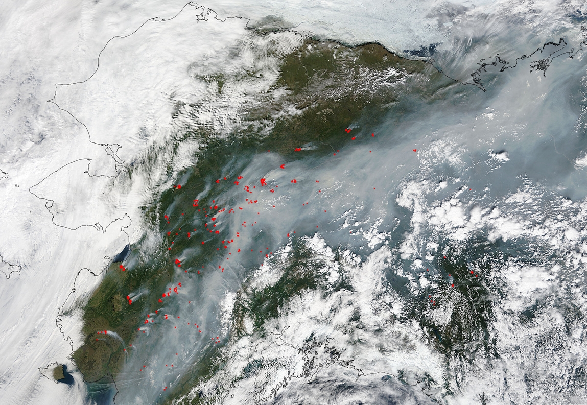
This natural-color satellite image was collected by the Moderate Resolution Imaging Spectroradiometer (MODIS) aboard the Terra satellite on June 25, 2015. Actively burning areas, detected by MODIS’s thermal bands, are outlined in red. NASA image courtesy Jeff Schmaltz, MODIS Rapid Response Team. Caption: NASA/Goddard, Lynn Jenner
Fire officials report on Wednesday, that the total fires burning in the state is now at 297. This total reflects three new fires. Included are 45 fires that are currently staffed and 250 fires that are currently being monitored. Staffed fires have burned approximately 461,734 acres thus far, while monitored fires have consumed 1,312,956 acres.
Galena Zone Fires
The 93 million acre Galena Fire Zone continues to lead with over 100,000 acres currently burning around the small communities of Ruby, Koyukuk and Nulato. 281 total personnel are on the scenes of these lightning-caused wildfires burning a combination of grass, mixed hardwood, tundra and Black Spruce.
Communication personnel were successful in placing a portable radio repeater to assist with long range communication.
Fire behavior on Nulato Fire moderated due to elevated humidity and lower temperatures. The Nulato fire, Nulato River Fire I, II, III, and the South Fork Fire have now merged into a single wildfire and will be treated as such.
The Bruno Fire was actively burning on all flanks.
The Big Creek Two Fire has burned actively on all flanks for the past several days. An attempt to place smokejumpers on the Big Creek Two Fire to engage in structure protection was unsuccessful due to smoke impairing visibility.
Tozitna Fire
The Tozitna Fire, that was detected on June 22nd, has now grown to 52,744 acres. Fires are actively burning in 35% of the perimeter and smoke settling in the area have hampered recon flights. The nine fires in the area are expected to grow moderately and the Jackson and Spicer Fires are expected to merge during the next burn period. The total of all fires in the Tanana area fires is now at 198,797 acres.
Safety Zones have been identified at the airport and along the Yukon River and voluntary evacuations continue via fixed wing aircraft and boat.
Chisana River II Fire
This fire has slowed with the advent of cooler weather, but still has reached 37,705 acres. The lightning-caused fire that began on June 9th is 22 miles southwest of the Tetlin National Wildlife Refuge Visitors Center and 25 miles west of Beaver Creek.
Firefighters will continue to protect identified cabins and monitor the fire’s behavior for growth and severity in the boreal forest where the fire is situated. This fire is expected to grow 2,000 to 2,500 acres in the next 2 days. It is expected that this fire will be contained by September 1.
Blair Fire
The Blair Fire was started by lightning as well on June 20th and is situated 39 miles southeast of Fairbanks. This 26,218 acre fire started on state land and moved onto military land. Cooler temps and rain have assisted in firefighting efforts near Delta Junction. No large increases are expected, but the fire will continue to creep to the east.
Rex Complex Fire
This complex of fires is situated approximately 6 miles to the northeast of Mile 275 of the Parks Highway. 25 evacuations have taken place with these fires and a number of residents are sheltering in place.
This complex has the potential of impacting several communities, the highway and railroad system as well as electrical and communication lines. It is currently at 16,519 acres but rains have kept the spread of the fire to a minimum. Continued rains have helped greatly with containment lines. Firefighters continue to make structure protection the priority.
Fire officials report that this fire is now 99% contained and has minimal or no potential for movement. Crews continue mop-up and back haul. Continued rain and showers are expected.
Card Street Fire
The Card Sttreet fire, which was human caused, is now 80% contained. Many of the campgrounds and trails in the area have been re-opened, although the Skilak Lake Road remains closed from the west entrance to the Engineer Lake Overlook. The Lower Skilak Campground and Boat Launch and Bottenintnin Lake day use area also remain closed. The road is open on the east end, to the upper Skilak Lake boat launch.
Eleven structures were destroyed including three residences.
Whitefish Lake Fire
The Whitefish Lake Fire, eight miles to the south of Kalskag, has grown 800 feet to the north and the north flank is fully active. Fire activity on the western flank of the fire picked up on Wednesday. Firefighters are working to keep the fire contained within the natural liquid barriers. This fire, started by lightning, is now 31,059 acres. They expect this fire to be fully contained in the immediate future.
North Aniak Fire
The lightning caused, 33,152 acre North Aniak Fire is now considered contained. It has bumped up against Kuskokwim River. Firefighters are meeting with community members of Aniak to address their concerns, mainly structures across the river from the community.
Firefighters are being demobilized from this fire.
Fires all along the interior have seen little or no growth with the cooler temperatures. Many of the fires there have been marked contained and many firefighterts are being demobilized.
The fire situation in Alaska is still very dynamic. There have been a higher number of fires than usual and fires have started earlier than normal. Many more structures have been threatened by this year’s fires than in the past.
Lightning strikes are responsible for a great many of the fires and the landscape was very vulnerable to this because of warmer than normal weather and light snowpack from the moderate winter.