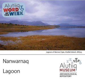
Cuumi suuget nayuryartaallriit nanwarnarmen. – People used to go hunt ducks at the lagoon.
The Alutiiq word for lagoon comes from the word nanwaq meaning lake. This is an apt description. Like lakes, lagoons are protected bodies of water. Most are separated from the ocean by some type of barrier—a sand bar, a reef, or even a set of islands. These features buffer wind and waves, creating calm waters and excellent places to launch and harbor boats.
Lagoons occur around the Kodiak Archipelago, but they are best known from the southwest corner of Kodiak Island. Here the mouths of the Karluk River, the Sturgeon River, and the streams draining into Grants Lagoon and Halibut Bay flow into shallow, triangular lagoons separated from the ocean by long cobble spits. The results are areas of shallow, brackish water where salmon congregate, seals feed, ducks rest, flounder flourish, and kayaks can easily land. Alutiiq ancestors settled these productive, strategic locations for thousands of years.
Despite their many advantages, Kodiak lagoons are geologically active. Winter storms periodically rework the cobble spits separating them from Shelikof Strait. When this happens, cobbles fill the river mouth and force water to cut a new exit. The river breaks through the spit in a new location, dramatically reworking its entrance. In Karluk Lagoon, this happened in 1978. A severe winter storm coincided with a monthly high tide. The Karluk River breached the lagoon’s cobble spit and formed a new mouth directly opposite Karluk village.
This powerful process destroyed a suspension bridge connecting the village to the spit, badly damaged the community’s school and chapel, and initiated years of intense shoreline erosion. Following the destruction, the Karluk Tribal Council voted to relocate the village. In 1980, with help from the US Department of Housing and Urban Development, residents moved into new houses located 2 km inland on the south side of the lagoon.
Source: Alutiiq Museum

